![[*]](images/clear.gif)
|
 |
| Scenic walks around North
Berwick | | Walk 2: Harbour to Fidra Island |
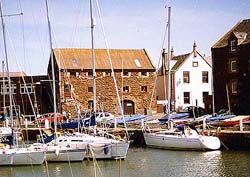
Harbour to Fidra Island
Start your walk at the harbour and proceed along the west beach where the golden sands lead to
Pointgarry Rocks. It was here that Robert Louis Stevenson played as a child with his friends as smugglers and pirates in a small
cave which you can still see today, but only at low tide.
Continue along the beach with the famous West Links golf course on your left and the three islands, Craigleith, Lamb and Fidra
on your right. Craigleith is owned by Sir Hew Hamilton-Dalrymple and run by Scottish Natural Heritage. It had one of the largest
puffin colonies in Britain with more than 28,000 pairs in 1999. Numbers were dramatically reduced to just a few thousand
following the invasion of the tree mallow weed. The mallow which can also be found on the Bass Rock is being managed by
volunteers and the puffin colony is slowly increasing.
From here you can see the spectacular sight of the Gannets diving into the water at speeds of over 90 mph. The impact as it hits
the water is so violent it can stun the fish, swallowing their prey whole before returning to the surface.
The Lamb Island, less than a mile offshore, is owned by Uri Geller, the famous spoon-bending psychic who bought the island in
January 2009 for 30,000 GBP. Geller claims the positioning of Fidra, Lamb and Craigleith, known in British mythology as the three
'Great Pyramids of Scotland' mirror the layout of the Pyramids of Giza, near Cairo. The connection is recorded in a 15th century
manuscript called the 'Scotichronicon' by Walter Bower the Abbot of Inchcolm which is regarded as a key text of early Scottish
history, and is housed in the National Library of Scotland. Geller visited Lamb Island in 2010 and left a number of items on top
of a box, including a crucifix, a compass bearing on the Egyptian Pyramids and inside the box was filled with bent spoons.
|
| Lamb Island
© Digitalsports |
|
According to research published by Jeff Nisbett in the magazine Atlantis Rising in September 2002, lines drawn between Scotland's
three important Templar sties – Temple in Midlothian, Rosslyn Chapel and the Isle of May - cut through Craigleith and Fidra with
the Lamb between them. The Isle of May is believed by some scholars to be the real location of Avalon, where King Arthur was laid
to rest.
Nisbett said the layout of the islands matches the three stars known as Orion’s Belt. He also discovered that anyone standing on
the battlefield of Bannockburn, where Robert the Bruce defeated the English in 1314 on-the anniversary of the battle on 24th June
would see three stars rise exactly over the three islands. As well as the connection to Arthur and Bruce, the line extended from
the Isle of May through the Lamb will cross Tara, burial place of the ancient Irish Kings.
The Lamb was previously owned by Brazilian internet entrepreneur Camilo Agasim Pereira who owned the title Baron of Fulwood and
Dirleton. The Lamb is home to the only breeding colony of cormorants in the region and is protected under UK law as a Site of
Special Scientific Interest.
Charles Stevenson the cousin of Robert Louis Stevenson wrote about the holidays they shared at North Berwick. There favourite
play area was this stretch of sand known as the Longskelly beach where the Eil Burn (called the Cressy Burn in RLS's novel
Catriona) enters the sea. In the 1860s the burn lay a mile west of the end of the golf course but today the Eil Burn cuts
through the 7th and 12th fairways and is an integral part of the course.
Beyond the Eil Burn is the board sands where the pilgrim ferry set sail for Fife. The name of the local farm Ferrygate is all
that remains from that period. At low tide near Longskelly Point the remains of HMS Ludlow can be seen, a former US Navy
Destroyer used for target practice during WW2. The Ludlow was decommissioned in June 1945 and towed to the broad sands from Rosyth
where it was beached. The Beaufighter planes stationed at East Fortune used the Ludlow for target training and following the
conflict the Ludlow was cut up by salvage contractors from Dunbar and only her keel and ribs can be seen today.
Leaving the golf course behind the high dunes on the left shelter Yellowcraig Wood with Fidra Island and its lighthouse on the
right. Fidra is owned by the RSPB and is home to a small population of guillemots, razorbills, herring gulls and puffins. Fidra
Island was the inspiration for Robert Louis Stevenson's famous book 'Treasure Island' with 'Spy-glass Hill' modeled on
Yellowcraig on the mainland opposite. The author spent many summers at North Berwick and was familiar with this area where he
also placed his characters David Balfour and Alan Breck when they reached the coast in his novel 'Catriona'. A map of Treasure
Island included in the first edition has the familiar horseshoe outline of Fidra. Stevenson landed several times on the island
to witness the progress in the construction of the lighthouse, built by his grandfather's engineering company in 1885 and
automated in 1970. |
| Fidra Island
© Digitalsports |
|
Local historian David Berry writes "The island is made up of the North and South Dogs (related to the German 'dogge'
and our 'dog' as a follower or companion) are skerries off the main island and are never connected to the main island at any state
of tide. The larger South Dog continues as a treacherous ridge towards Eyebroughy and means boats must stand well out when coming
round the SW corner. The smaller North Dog lies under the lighthouse and is almost submerged at spring full tide. The part to the
SE that is separated from Fidra proper at high tide is Castle Tarbert (from the gaelic Tarbeairt, an isthmus or portage). Eilbotle
(from the Anglian for 'old settlement') was on the nearby shore, which is why the wood has that name.
Only a stave keep, the later chapel and perhaps some small buildings were on the island itself. Just who lived here is a
fascinating conundrum because after the Goddodin fell in the 7th century, this must have been a no-man's-land among Angle,
Pict, Brython and Viking, with Fidra an important outpost on the coastal sea-routes (easy to get to, big enough to be
comfortable & support some livestock, hard to assault). There are stories of 'the race of Congals (from Congalton?) being
slaughtered here by Vikings in the 9th century and the hill in Yellowcraig wood was probably another stave fort but less secure
that Tarbert. However, no serious archaeology has been done to substantiate any of this. What fascinates me is the mix of
origins of local place-names from all their languages, which must mean they all settled--you don't get your name for a place
into use just by passing through."
| "In February watch the surfers 'catch-a-wave' off the broad
sands" |
Turn inland at Yellowcraig and follow the single track road to Dirleton where the regular bus service takes you back to North
Berwick. Alternatively continue walking along the shore beyond Archerfield to Gullane where refreshments and transportation
is available.
Harbour to Fidra Island - 3 miles, one hour walking time. |
Copyright © Douglas C. Seaton, All Rights Reserved. | |

![[Lamb Island]](images/lamb.jpg)
![[Fidra Island]](images/fidra_3.jpg)